Global climatic stability hinges upon a delicate equilibrium between oceanic currents and thermal regimes. The resurgence of El Niño destabilizes this balance, triggering a cascade of meteorological anomalies on a planetary scale. Advanced satellite altimetry now enables the detection of these shifts well before they escalate into full-scale environmental catastrophes; consequently, the analysis of minute fluctuations in sea levels has emerged as a critical instrument for forecasting systemic global climate risks.
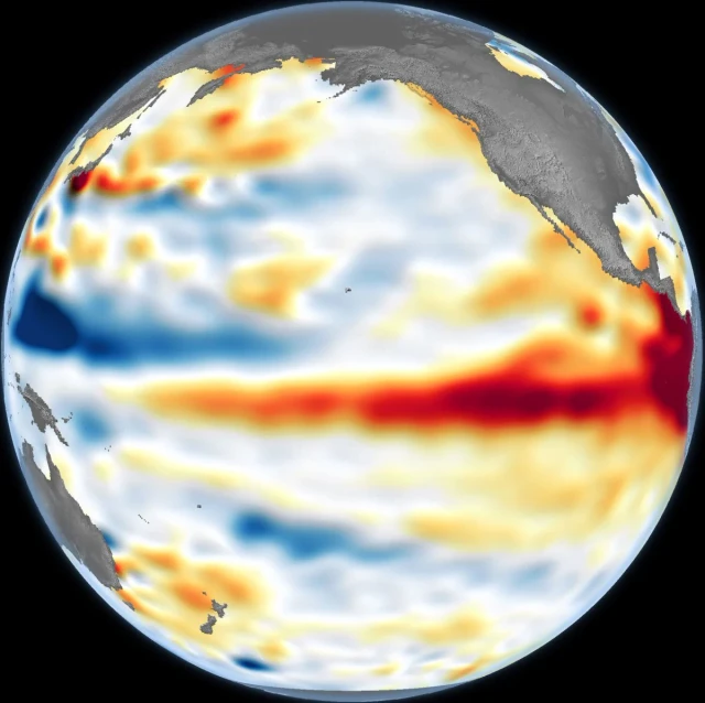
In June 2026, the global scientific community recorded the resurgence of El Niño, one of Earth's most influential climatic cycles. The first indicators were anomalously warm waters in the central and eastern regions of the equatorial Pacific. Official confirmation followed once sea surface temperatures exceeded the norm by at least 0.5°C for several consecutive months. However, for specialists at NASA's Jet Propulsion Laboratory (JPL) and their partners, the deciding factor was not merely the temperature gradient, but a shift in the very geometry of the ocean.
The methodology relies on a fundamental physical principle: thermal expansion. As massive volumes of warm water migrate across the Pacific, they trigger a subtle yet statistically significant rise in surface levels. The Sentinel-6 Michael Freilich satellite, a joint venture between NASA and the European Space Agency (ESA), is capable of registering these microscopic height fluctuations with exceptional precision. For climatologists, such data is critical; it allows them to quantify the volume of heat accumulated beneath the surface, which correlates directly to El Niño's energy potential and its capacity to dictate weather patterns in the coming months.
The formation of this phenomenon is not instantaneous. As early as the spring of 2026, monitoring systems detected the movement of so-called Kelvin waves—powerful pulses of warm water propagating eastward through the equatorial zone. These waves serve as the primary precursors to the climatic shift. They emerge when the trade winds—the prevailing winds that typically push water toward Asian shores—weaken or shift direction. Consequently, the thermal energy accumulated in the western Pacific begins to "drain" back toward the Americas.
As this warm mass advances eastward, it fundamentally transforms the ocean's structure: the upper warm layer thickens, and the thermocline—the boundary between the mixed surface waters and the cold deep-sea layers—shifts deeper. This suppresses natural upwelling, the process by which nutrient-rich cold waters rise along the coasts of North and South America, leading to severe repercussions for marine ecosystems and commercial fisheries.
The true value of sea-level data lies in its ability to distinguish transient temperature spikes from profound structural changes. A thin layer of warmed water can dissipate quickly under external pressures, but a deep reservoir of heat possesses immense inertia. It is this "energy buffer" that sustains the duration and intensity of El Niño, evolving it from a localized oceanic event into a global climatic trigger.
The consequences of this process extend far beyond the tropics. Through complex atmospheric teleconnections, changes in the Pacific redistribute precipitation and temperature flows worldwide. For the Southwestern United States, this often manifests as excessive moisture and flood risks, while Indonesia and Australia face severe droughts and wildfires. The peak impact typically occurs during the Northern Hemisphere's winter, when the tropical impulse fully destabilizes established storm and cyclone trajectories.
To extract clean data, scientists employ sophisticated filtering algorithms to strip away seasonal oscillations and long-term global sea-level rise trends. This allows them to isolate the short-term El Niño signal from the general noise of planetary processes, transforming satellite altimetry into a high-precision instrument for predicting the future of our climate.
 A Pragmatic Approach to Lunar Equipment Design